


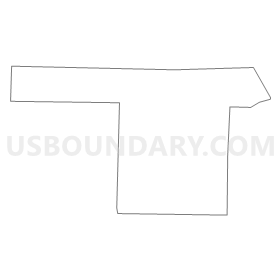
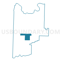
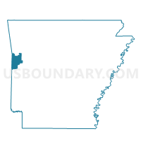
Voting District 9-3-F, Sebastian County, Arkansas
About
Outline
Summary
| Unique Area Identifier | 528183 |
| Name | Voting District 9-3-F |
| County | Sebastian County |
| State | Arkansas |
| Area (square miles) | 16.57 |
| Land Area (square miles) | 16.46 |
| Water Area (square miles) | 0.11 |
| % of Land Area | 99.34 |
| % of Water Area | 0.66 |
| Latitude of the Internal Point | 35.14269440 |
| Longtitude of the Internal Point | -94.28319300 |
Maps

Graphs
Select a template below for downloading or customizing gragh for Voting District 9-3-F, Sebastian County, Arkansas


Neighbors
Neighoring Voting District (by Name) Neighboring Voting District on the Map
- Voting District 9-2-D, Sebastian County, AR
- Voting District 9-3-B, Sebastian County, AR
- Voting District 9-3-E, Sebastian County, AR
- Voting District 9-3-G, Sebastian County, AR
- Voting District 9-3-I, Sebastian County, AR
- Voting District 9-4-I, Sebastian County, AR
Top 10 Neighboring County Subdivision (by Population) Neighboring County Subdivision on the Map
- Center township, Sebastian County, AR (10,762)
- Cole township, Sebastian County, AR (1,908)
- Diamond township, Sebastian County, AR (1,156)
- Jim Fork township, Sebastian County, AR (1,000)
- Prairie township, Sebastian County, AR (877)
- Dayton township, Sebastian County, AR (731)
Top 10 Neighboring Unified School District (by Population) Neighboring Unified School District on the Map
- Greenwood School District, AR (19,838)
- Mansfield School District, AR (5,565)
- Hartford School District, AR (3,169)